Mt Ericsson, Kings-Kern Divide
Notes by piero scaruffi | Other California destinations | California hikes
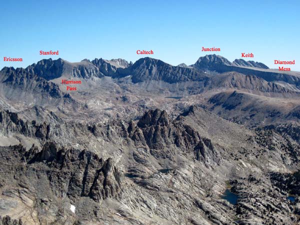
Roads End to the Kings-Kern DivideThe Kings-Kern Divide is a steep ridge that separates the birthplace of the Kern River (an idyllic group of lakes) and one of the birthplaces of the Kings River (Lake Reflection). Its eastern peak is Mt Stanford, its western peak is Thunder Mountain
In between there are three major peaks: Mt Jordan, Mt Mt Genevra (3979m), and Mt Ericsson (4140m). In between there are also four ways to cross the divide: Milly's Pass (3730m), the Weyman chute (3852m), Lucy's Pass (3780m), and Harrison Pass (3880m). From the south the Kings-Kern Divide can be easily reached via the class-2 slopes of Milly's Pass, Lucy's Pass and Harrison's Pass. However, from the north all of these passes are much tougher. Alas, the natural approach to the Kings-Kern Divide is from the north, either from Roads End or Onion Valley, via East Lake and Lake Reflection (3057m).
The distance from Roads End to Reflection Lake is about 23kms. The trail is well-maintained to East Lake (but read about crossing the creek here) and marked with cairns beyond that. If you are heading for Lucy's Pass or Harrison's Pass (despite what i just wrote), best is to leave the trail about 30 minutes south of East Lake and just before the tributary that comes down from the eastern peaks. This tributary causes a number of small crossings on the trail between East Lake and Reflection Lake. Shortly before this watery part, the trail requires 50 meters of bouldering. You are best off leaving the trail exactly before the bouldering section. Leaving the trail just before this bouldering/watery part (about 2 kms before Reflection Lake), one climbs up a steep slope to the left. If you are lucky, you will hit a use trail (which may or may not be the old unmaintained trail) that will make your life easier. More and more cairns mark the route as you climb up the steep switchbacks of this use-trail. If you can't find it, just coast the creek to the north and you'll get to the oblong lake from which it flows, Lake Jimi Hendrix. Coast Lake Jimi Hendrix to the left/north (you may find a sort of natural "road", a wide flat path) heading southeast. There is a tiny lake above to the left. Ideally you want to head for the land between the two lakes. If you picked the right route, you'll enter the moraine of Lucy's Pass above the oblong lake at a vantage point. Now cross the creek that comes down from the east and turn right (south) into the moraine that heads to the wall of Lucy's Pass. A series of hilly formations lead gradually to the wall, but the wall is really what it appears to be: a hellish class-3 climb on extremely slippery and loose rocks. On the way down this "pass" can be fatal, especially if you have a huge backpack. The direction of Lucy's Pass from the Reflection lake trail:
Stay between the two lakes:
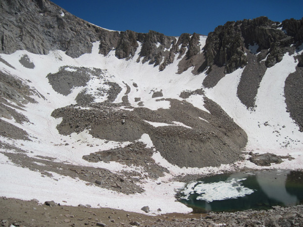
For Harrison Pass, don't cross the eastern creek (don't cross the creek and don't enter the Lucy's Pass moraine) and just continue east following the creek upstream. The terrain will get easier. Head east and you'll be facing the massive western face of Mt Deerhorn. After passing between two large lakes, Deerhorn 1 and Deerhorn 2, the route turns south towards Harrison Pass. You still don't see the pass because there is a colossal wall in front of you with rapids in the middle. Once you reach the top of this wall, you are at the twin lakes, the glacier of Mt Stanford. As you look south, Stanford is the mountain to your left, Ericsson to your right. Harrison Pass is the 800-meter barrier that separates the two. That is a steep climb, and often involves going around snow/ice even in summertime because it faces north. Mt EricssonWhen you reach the top of the Weyman chute or the top of Lucy's Pass, Mt Ericsson is the mountain to your left (east). Just head straight up the face:
Mt Ericsson has several summits.
The register is on relatively flat one (compared with the other peaks, that
are sharper pyramids).
The very summit requires some scary class-3 moves.
This is the chute to the top viewed from Harrison Pass:
This is how it looks when you are heading up (the summit is to the right of the notch):
Milestones:
|
Pictures of these hikes
My page on Kings Canyon hikes Links:
Driving directionsDirections for Roads End from the Bay Area. Take 101 south, 152 east lo Los Banos (about 1 hr 30') to 99 (about 2hr), 99 south to Fresno (about 300 kms, 2h 30'). In Fresno, take 180 east and follow it (the freeway is not completed yet, it will go through town and then turn left into Kings Canyon Ave) to the Big Stump park entrance (85 kms, 1h 15') to the fork with Sequoia Park (5') to Grant Grove village (3kms, visitor center, restaurant, water, restrooms, market) to Cedar Grove (50 winding kms, 50', via Kings Canyon Lodge 20', Boyden Cavern 30', Kings Canyon border 40') and then (10 kms) Roads End. Park at Roads End, at the first parking lot, marked by the sign "Information".
Camping near Roads EndSeveral options:
FoodDon't count on food once inside the park. There are only two or three restaurants and they are likely to be closed when you need them. |