Hiking the Middle Palisade
Notes by piero scaruffi | Travel resources | Hiking in CaliforniaPictures of the hikes | Middle Palisade' weather
|
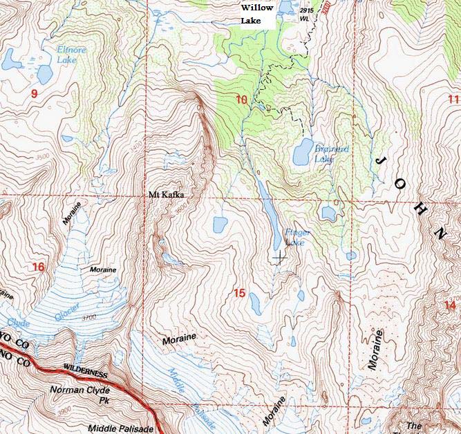
The Palisades region of the Sierra Nevada is located west of the town of Big Pine. It includes some of the highest mountains in California, including the Middle Palisade (4271m). The main approach to Middle Palisade is via Big Pine's "south fork". From hwy 395 in Big Pine (130 kms, about one hour) take the only road that goes west (right), Glacier Rd. The trailhead parking lot for the "north fork" is almost at the end of the road (before Glacier Lodge) on the right handside. There is a campground about 200 meters before this trailhead on the left handside. At the end of the road there is a parking lot for the Glacier Lodge that can be used also for day hikes. That is the trailhead for the "south fork", the trailhead you want. This South Fork trail starts at the Glacier Lodge (2300m) and reaches Willow Lake in 6.5 km at 2900m of elevation. At the beginning you walk between the river and a residential area. Then pay attention to signs that direct you to the South Fork trail, and memorize these trail signs because on the way back one can easily make the wrong turn. The trail initially gains little elevation. Note that soon (in less than one hour) you have to cross a creek that may be impassable after a rain or in early summer when a lot of snow is melting. (The national forest has money to hire rangers to check your permits but doesn't have money to place a couple of logs on this creek). Here to the south one has the first clear view of the Middle Palisade, with Norman Clyde Peak to the right and Disappointment Peak to the left. The trail dead ends at Brainerd Lake but a use trail winds its way up to the west and then south to Finger Lake. Follow the gentle slope above Brainerd Lake between pine trees. Coast Finger Lake to the left (there's a little cliff than can be easily climbed) all the way up to the waterfall. Climb around the waterfall and you find yourself in a basin with a little pond. Coast the pond to the right and enter a wide gully. To your left is a wall of slippery granite that is best avoided. The gully is full of loose scree.
After a waterfall that originates underground, turn left and reach the
glacier.
You are below the Secor chute.
Once you are safely above the snow, if you head slightly to the right you will
enter the Secor (north) chute. This chute is class-3 and
eventually intersects the main chute coming from the "red rocks"
that heads straight up to the top.

Norman Clyde PeakMiddle Palisades sits between Disappointment Peak (4242m) to the south and Norman Clyde Peak to the north. Disappointment Peak is class-4 from whichever side you try it. Norman Clyde Peak is more easily climbed from the south, which involves climbing Scimitar Pass, but even from the south it still has class-4 sections.
Mt KafkaJust before you enter the Middle Palisade glacier, to your right, almost exactly south of Mt Clyde and northwest of Finger Lake, there is a lower mountain that i named Mt Kafka (3748m). It separates the Mt Sill glacier and the Middle Palisade glacier, with great views of both sides. It is relatively easy to climb from Finger Lake: once at the southern end of the lake, move to the right and start climbing as you keep heading southwest. |