Mt Tamalpais
Back to hiking in California | Bay Area hikes | Pictures of these hikes | Pictures of the world
Trails in the Mt Tam region
Muir Woods to Stinson Beach to Mt Tam
This route (that i first experimented in january 2007) combines the Matt Davis, the Steep Ravine and the Dipsea trails, three of the most popular trails of Marin County, with the 360-degree view from the summit of Mt Tam and a stroll through the giant sequoias of Muir Woods. This allows for an unusual diversity of landscape, vegetation and views. Trailhead: Mountain Home Inn on the Panoramic Highway. From 101 north of the Golden Gate Bridge take the Hwy 1 exit and follow the signs to Mt Tamalpais till you see the Mountain Home Inn on your right handside. The parking lot is on the left. Route. The beginning is downhill along the Panoramic trail, right into the Ocean View trail, on to the headquarters of Muir Woods. In the parking lot of the park (right handside), take the Dipsea trail up to the Pantoll parking lot. This is mostly uphill. Cross the paved road and take the Steep Ravine trail down towards the coast (this goes through the ladder) and then turn right into the Dipsea trail towards Stinson Beach. Once in Stinson Beach, the trail crosses the paved road. You can follow it to downtown or keep walking on the paved road to the beach. Eventually look for Belvedere Ave (the fire station). Walk up Belvedere Ave and the parking lot for the Matt Davis trailhead is right there on the right. Follow the Matt Davis trail from Stinson Beach up to Pantoll (past the junction with the Coastal trail). Initially it winds its way up into the forest, and it is quite steep. Then it emerges into grassland with terrific views of the ocean and of San Francisco, and it proceeds relatively flat to the Pantoll parking lot. When you reach the Pantoll parking lot, cross the street and take the Stage Road (which is paved at the beginning) right after the new trailhead for the Matt Davis trail. This is a gradual ascent with more views of the ocean and the Bay. At the West Point Inn, turn sharply left (uphil) into the Old Railroad Grade. This ends at the bottom of the parking lot for the East Peak summit. When you reach the East Peak parking lot, you still have to climb about 10 minutes with all the tourists to reach the very summit of Mt Tamalpais. After enjoying the 360-degree view (fog permitting), descend back to that parking lot and look for the Fern Creek trailhead on your left handside (southern side of the parking lot). Descend on the very steep Fern Creek trail, left (east) on Old Railroad Grade and after 500m right (south) on Hogback (extremely steep and slippery). At the fire station a sign sends hikers left into a narrow trail but if you just continue straight through the fire station you reach the Mountain Home Inn parking lot in five minutes. Milestones and distances (does not include breaks):
Three-lake hike to Mt Tamalpais
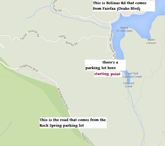
The Cataract Trail is very popular because of the impressive views of the cataracts (not in summer, of course, when they are dry). Ideally, make a loop that includes cataracts, summit and the three lakes. As you go up the (steep) Cataract Trail, pay attention to the junction with the Helen Markt Trail, which is where you'll come from on the way back. The cataracts last quite a bit. After the Laurel Dell picnic area the crowds disappear. Turn left at the junction with the Dell fire road and follow it to the Potrero Meadow. This is a small picnic area. Head towards the restrooms and take the unmarked trail to the right (not easy to spot in 2023). It crosses a large meadow and eventually hits a fire road. Turn left and Rifle Camp is a short distance. Go through the picnic area, and then immediately right into the Upper Northside trail (the sign is not very visible, but it is just 20 meters from the picnic area - look for the bridge). The Northside trail eventually reaches the Inspiration Point, a major intersection: take the rightmost trail straight to the top. It will end on a paved road, which is 100 meters from the parking lot. Besides the parking lot there is a wooden trail that leads to the very top. Returning can be done faster via a straight trail that goes down directly to Lake Lagunitas, the Collier trail. From the top, walk down the parking lot on the paved road to the second gate on your right handside. This is the Lakeview trail that coasts the paved road. Continue on this trail (or, better, fire road) until a sharp left switchback (that would take you to the middle peak). On the right handside of this switchback is a much narrower trail that takes you to the paved road. Walk 20 meters on the paved road to the trailhead for the International trail (don't ask me why you have to walk 20 meters on the paved road...). Take that one downhill, but after a short distance turn sharply right into the Collier trail. This trail coasts the creek all the way down to Lagunitas Lake. It intersects the Northside trail at a picnic area. Just continue straight downhill on the left handside of the creek. Eventually it crosses to the right handside of the creek. It is very steep. Further down in the rain season you may have to wade two creeks. (If you are looking for the Collier trail from the Lagunitas Lake parking lot, walk towards the lake, then turn either right or left at the first junction at the beginning of the lake. If you turn left, go over the little dam, then keep coasting the lake ignoring all the junctions. Eventually you'll see the well-marked junction with the Collier trail after the Lagunitas Spring trail junction). Once you are at the bottom take a left on the unmarked junction, otherwise you get to the parking lot for Lake Lagunitas. You recognize this junction because it has a bridge over the creek. It is the Shadyside Trail but you will find out only later. This trail continues to coast Lake Lagunitas and you will see the dam on your right. Keep going. When you get to a bridge, stop and walk back 5 meters: take the trail. You are now coasting Bon Tempe Lake. This is fairy flat. When you get to the end of this lake, you will see a strip of land (which looks like a highway or a runway) separating Bon Tempe from Alpine: it's the Bontempe Dam. Go straight/left. You get to a junction almost immediately: go right and keep coasting Alpine Lake. Eventually this fire road dead-ends and you continue on a trail, Helen Markt Trail. This trail starts climbing steeply and will continue to climb for an eternity. Eventually (after crossing two creeks, dry in the summer) it intersects the Cataracts Trail. Turn right and steep downhill to your car.
Dipsea TrailTrailead: Old Mill Park in Mill Valley, CA. Directions: cross the Golden Gate bridge and continue north on 101. Take the Hwy 1 exit and go west. At the fork, bear right (Miller Ave). Turn left on Throckmorton to Old Mill Park. The trail begins at the base of the stairs (671 steps) in Mill Valley. At the top of the stairs, turn on Sequoia Rd and walk up Walsh Dr. Cross the Panoramic Highway which heads to to the lower parking lot of Muir Woods park. Or you can begin the hike from Muir Woods. To make it more interesting, one can also climb Mt Tam. Highly recommended. On weekend days, there should be bus service (Golden Gate Transit Agency) which takes you back to about 1 km from the original starting point. Mt Tam from the Temelpa trailCross the Golden Gate bridge and continue north on 101. Take the Hwy 1 exit and go west. At the fork, bear right (Miller Ave). Turn left on Throckmorton to Old Mill Park, right on Olive, left on Lovell and right on Summit. Drive to the end of Summit Ave, turn into Fern Canyon Road (Map) and meet at the trailhead of the Temelpa Trail (Picture of the trailhead). From there it is a short (1 km) ascent to Mt Tamalpais, which offers one of the greatest views in California. From the Mountain Home fire station |

|


