Sphinx Lakes in Kings Canyon
Notes by piero scaruffi | Other California destinations | California hikes
This is one of the most massive of my day hikes. It involves a significant
elevation gain (1600m at the trailhead, 3600m at the last lake), a
steep approach via the Sphinx Creek trail, and several hours of cross-country
hiking ("the trail you make is the trail you take"). One has to deal with
pretty much all different kinds of terrain: sandy trail, rocky trail, foresty
trail, bushwhacking, granite slab and finally tallus rock.
The total distance from the trailhead to the last Sphinx Lake (which I call
Sphinx 7) and back is about 42 kms, the distance of the marathon.
Needless to say, it is worth it because the Sphinx lakes basin is one of
the most spectacular sights in all of California.
Trail descriptionIf you parked at Roads End, at the first parking lot, marked by the sign "Information", the trailhead is right in front of the tiny ranger station (at an altitude of about 1600m). There is a water fountain right at the trailhead.Starting at the ranger station of Roads End (next to the water spigot), you will follow signs for Bubbs Creek, Sphinx Creek Junction and then for Avalanche Pass. After three tedious kms (about 20 minutes) of very wide flat sandy trail, you reach the first fork (Paradise Valley). Bear right and walk over a series of five bridges. (Note the sign at the creek crossing after the first long bridge: there is a fork that will not be obvious when you are coming down, especially after dark. It is not even obvious where the trail continues if you are hiking up, especially if you are hiking in the dark, and most of the year it is not obvious at all where to cross the creek). You are on the Bubbs Creek trail going east. Steep switchbacks take you in 3 kms (1 hour 10') to another junction (Sphinx Camp N36.79352 W118.52838). The Bubbs Creek trail continues east, but you want to turn right into the Avalanche Pass trail, aka Sphinx trail (the "sphinx" is right on top of you, on the other side of the creek). Walk over the bridge and ascend the extremely steep trail to the top of the mountain in front of you. For the whole way you are flanked by rapids and waterfalls. At the top (about 1.5 hours, so about 3 hours from Roads End) the trail turns right and crosses a very small creek. Then it bends left and goes up a little less steep but straight roughly south. At some point it flattens out and even starts descending a bit as it approaches the Sphinx Creek. Now you need to leave the trail and there are two ways to go about it.
Sphinx Lake 1 is marshy on the right/western side (and the eastern side looks a lot less friendly). If you coast the marshy side, you may find the vestige of a trail and get to another wall of boulders, to the right of the creek. There is again a vestige of a trail, steep switchbacks leading to a foresty area which hides the second lake, Sphinx Lake 2 (5 hours, 3186 meters). Coast Lake 2 to the right (west) following a use-trail. When the trail ends, just scramble up the boulders in the general south direction. The twin lakes (third and fourth lake) are right above your head but you want to aim for the lowest point of the crest in front of you, which is to the left of your route. First, you have to climb above some intimidating cliffs. You can go around them to the right or you can use a steep notch. Then move to the left (i.e. towards the water) as you go up in order to hit the outlet of the lakes.  I call these lakes the "twin lakes" (about 3300m): they are one next to the other, separated by a thin strip of rocks and vegetation. You should first get to Lake 3 (N36.72783 W118.51811). You should find a trail on its northern shore that heads west to Lake 4. The two lakes communicate. Use either logs or islands to cross to the southern side of the twin lakes. If you look up/south, you should see two canyons in front of you, separated by an oblique pyramid.  The canyon on the left/southeast side dead-ends in a brutal semicircle of peaks (North Guard towers above this amphitheater). There are actually two main lakes up here (which i call Sphinx 8 and Sphinx 9) and the higher one seems to have ducks every summer. The canyon on the right/southwest side offers an affordable grade over a green patch along the creek. This is the side that you want to take if you want to see Sphinx 5,6,7 and reach Sphinx Pass.  You can walk up that green patch (actually, a lot of boulders and shrubs), basically following the creek, or (better in my opinion) you can walk straight up the promontory that separates the two canyons, slightly on the western side of the oblique pyramid.  This way you are walking above the western canyon. The first advantage is that you get to see the two lakes on the left canyon (which most people miss). The second advantage is that this route is less uneven than the valley below. The third advantage is that you walk above the lakes. As you keep moving southwest, entering the southwest canyon on its left/east side, you should see to your right two tiny ponds, then Sphinx 5 (N36.71849 W118.51505), then Sphinx 6, and finally the last pond (usually icy and surmounted by snow), which I call Sphinx 7 (about 3500m, 7.5 hours). In front of you (south) there is a wall of boulders surrounded by vertical peaks on both sides: that is what i call Sphinx Pass (N36.71091 W118.50401).  It takes about one hour to climb Sphinx Pass (just boulder hopping to the top), with the view of the last three Sphinx lakes behind you.  At the top, you get a wonderful view of Mt Brewer and North Guard to the southeast and the South Guard to the south, and the Brewer basin right below you.  You don't see Big Brewer Lake which is slightly to the right (southwest) of the pass. Coming back down is going to be faster (about one hour to the twin lakes, one hour to the first lake, one hour to the trail) but not much faster (once on the trail, it takes about the same 3 hours to get to the Roads End parking lot). There is, needless to say, plenty of water along the way, so you don't need to carry much. There is drinkable water at the trailhead (right by the little ranger station). From the parking lot to where you leave the trail:  (Topoquest)
The Sphinx Lakes:
|
Pictures of this hike: click on Sphinx Lakes.
Mt Brewer and the Great Western Divide from Sphinx Pass, Kings Canyon (video) Sphinx Lakes in Kings Canyon National Park (video) 
(click to enlarge) Driving directions to Roads End from the Bay Area.Take 101 south, 152 east lo Los Banos (about 1 hr 30') to 99 (about 2hr), 99 south to Fresno (about 300 kms, 2h 30'). In Fresno, take 180 east and follow it (the freeway is not completed yet, it will go through town and then turn left into Kings Canyon Ave) to the Big Stump park entrance (85 kms, 1h 15') to the fork with Sequoia Park (5') to Grant Grove village (3kms, visitor center, restaurant, water, restrooms, market) to Cedar Grove (50 winding kms, 50', via Kings Canyon Lodge 20', Boyden Cavern 30', Kings Canyon border 40') and then (10 kms) Roads End. Park at Roads End, at the first parking lot, marked by the sign "Information".Region's map (Google Earth):
CampingThere are many campgrounds along the road, and at least 3 near Cedar Grove. Needless to say, they are all full in the summer on fridays and saturdays. It is legal to camp anywhere in the national forest (not in the national park). Luckily the road to Cedar Grove crosses a large section of national forest. Just find a place where you can park safely off the pavement, and you can pitch your tent anywhere. For example, the many turnouts just before you re-enter Kings Canyon national park at Cedar Grove; or the Deer Cove trailhead. Rangers told me that it is illegal to sleep in the parking lots of Roads End (although it seems to me that this should be the environmentally friendly thing to do, but bureaucracy has a unique way to complicate simple things,and to cause more damage to nature than vandals). Summary of the hike
Loop via Avalanche PassYou can do a loop via Avalanche Pass. Cross over Sphinx Pass and turn right into the canyon that drains Big Lake Brewer. Stay high on the right side (north side) of Big Brewer Lake which now becomes very visible. The ridge on your right side goes down west. Before you reach the next lake (you should still be high to the right of it), turn around the ridge to the west and then north (the ridge should now be low enough that you should neither lose nor gain elevation). If you keep in the general direction northwest at 2800 meters of elevation, you should eventually cross the Moraine Creek. At this point you can either head northwest and hit the trail below you (but you lose a lot of elevation) or keep following use trails and animal trails that coast the mountains on your right and head north. The first drainage on your right is the Moraine Creek drainage. Continue north to the next drainage, which is the correct one. Mt Palmer should be in front of you. The use trails should eventually hit the Avalanche Pass trail (around N36.73745 W118.55969). At that point ascend the trail to Avalanche Pass and then follow it downhill back to the starting point.  (Everytrail.com)
Another possible loop is to reach East Lake via the lakes south of Sphinx Pass  through this pass visible from Sphinx Pass: 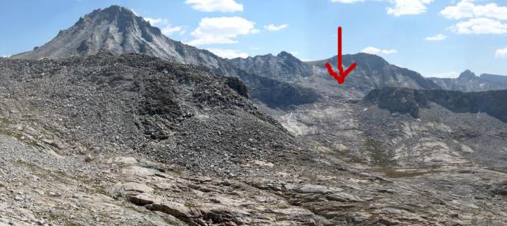 See also climbing Mt Brewer from the Sphinx Lakes. |


