From Onion Valley to University Pass to Kearsarge Pass
If you would like the original, high-resolution pictures, contact me
Notes of this trip | Back to California hikes | Pictures of the world
 The official trail is not much of a trail |
 View of Onion Valley from the trail |
 The trail as it dead-ends at Lake Robinson |
 At Lake Robinson |
 At Lake Robinson |
 Lake Robinson |
 Lake Robinson |
 The two University passes |
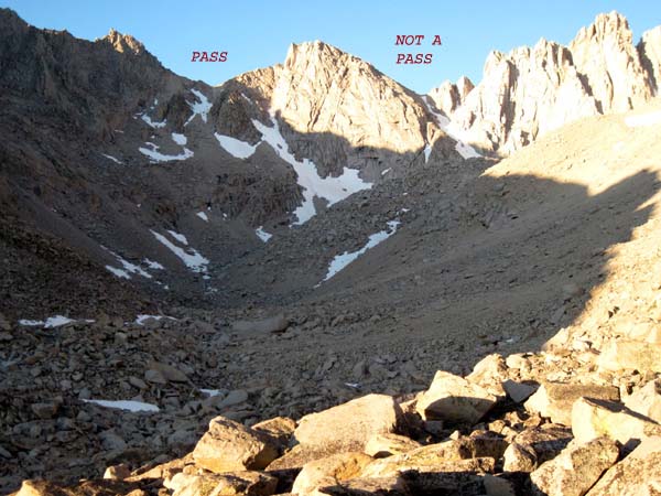 The two passes |
 Your plastic bottles at work (please don't buy plastic) |
 The rightmost pass (don't do this: it is a stupid idea) |
 Wildflowers |
 Climbing the rightmost pass |
 Climbing the rightmost pass |
 Climbing the rightmost pass |
 Climbing the rightmost pass |
 The pass from the rocky ridge to its left |
 University Peak to the right |
 The other side: looking south to Mt Keith and (behind it) Mt Williamson |
 Center Basin to the left |
 Center Peak and behind it Forrester Pass and behind it Caltech Peak |
 The two valleys divided by Center Peak (Mt Stanford in the right one) |
 View northwest |
 Climbing down the pass |
 The lake at the bottom |
 The lake at the bottom |
 Center Basin all the way to Mt Keith |
 Another lake in Center Basin |
 Center Peak |
 Mt Stanford |
 A little detour in Center Basin |
 A little detour in Center Basin |
 The passes from below |
 The chutes from below |
 The passes from below |
 Center Basin |
 Center Basin |
 Mt Keith |
 Mt Keith |
 Mt Keith |
 Center Basin |
 Mt Keith |
 Center Basin |
 Center Basin |
 Center Basin |
 Center Basin |
 Center Basin |
 Center Basin |
 Center Basin |
 Center Basin |
 Center Basin |
 Center Basin |
 Center Basin |
 Mt Keith |
 Looking north |
 Looking north |
 Looking south (southern neighbors of Mt Stanford) |
 Looking south |
 Looking north |
 Mt Stanford |
 The John Muir trail |
 Center Peak |
 Looking south (in the middle the fist-like peak) |
 Crowds on the JMT |
 Heading north on the JMT |
 Heading north on the JMT |
 Heading north on the JMT |
 Heading north on the JMT |
 Heading north on the JMT |
 Heading north on the JMT |
 Heading north on the JMT |
 Heading north on the JMT |
 Heading north on the JMT |
 Heading north on the JMT |
 Vidette Meadow |
 Vidette Meadow |
 Vidette Meadow |
 Climbing towards the Kearsarge Basin |
 Climbing towards the Kearsarge Basin |
 Climbing towards the Kearsarge Basin |
 Center Peak in the middle |
 Climbing |
 Climbing |
 Climbing |
 Climbing |
 Climbing |
 At the basin |
 At the basin |
 At the basin |
 Bullfrog Lake |
 Bullfrog Lake (Kearsarge Pass is the lowest point you can see on that ridge) |
 Bullfrog Lake |
 Bullfrog Lake |
 Towards Kearsarge Pass |
 Towards Kearsarge Pass |
 Towards Kearsarge Pass |
 Towards Kearsarge Pass |
 Towards Kearsarge Pass |
 Towards Kearsarge Pass |
 Kearsarge Pass |
Back to California hikes
If you would like the original, high-resolution pictures, contact me