Double Cone, Ventana Wilderness
Back to hiking in California | Back to Bay Area hikes | Back to travel } Pictures|
The Double Cone
(1479 m) [GPS: N36.29710/W121.71487]
is located in one of the most remote regions of the Ventana Wilderness.
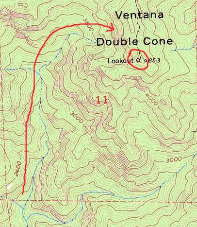
Whichever way you go, keep in mind that this area is famous for gorges. The property of gorges is that the walls are extremely steep. Focus on the fact that it usually takes longer to go back down than it took to climb up. Things you shouldn't forget on these hikes in spring, summer and fall: insect repellent, gloves, and something to wipe out sweat. Cover your body as much as possible (ticks, flies, poison oak, thorny shrubs, sharp dead wood). Note: the top of Double Cone is famous for fog that flies in from the ocean. There are very few afternoons that are free of fog. You need to summit in the morning to maximize chances of a clear view. 1. From Bottcher's Gap via Pat's SpringsTrailhead: the end of Palo Colorado Rd. Take Hwy 1 south from Carmel, and (after about 20 kms) turn left into Palo Colorado Rd (just after Rocky Point Rd). The road is paved but very narrow and winding. The campground is at the very end. There is a fee ($12 in 2008) to camp. The trailhead to the Pat Springs route (the only one that has an official trail to Double Cone) is *not* the very visible fire road (usually gated) but the trail that leads to the walk-in campsites. During the day it's very easy to spot the sign "Skinner Ridge Trail". Note of 2017: Palo Colorado Rd is closed. Click here for a detour to reach Devil's Peak while the road is closed.
The trail gains elevation very quickly to reach a summit with the first
views of the wilderness on the northern side. The Ventana Double Cone is
actually visible from Bottcher's Gap to the southwest. From this
summit the trail descends a bit and starts climbing
to Devil's peak. The terrain here is completely different: rocky instead
of foresty. This is also one of the few spots where shade is minimal.
Then the trail descends again (there is an unmarked junction about 500m after
the peak, and you have to continue going down the ridge, i.e. a sharp 90 degree
right turn, instead of heading straight into
the forest) and later rises a third time to the eastern ridge
near Pat's Spring. Note: as you approach the creek there are two junctions
(about 2kms from each other) that take to Big Pines
and it is not obvious how to stay on the trail to Double Cone.
You get to an infamous five-way junction with no signs.
Counterclockwise you have: a trail that comes from Bottcher's Gap, a trail that leads to the campsites uphill, the trail to Pat's Spring, the trail to Double Cone (alas, the faintest of them all) and the trail that comes up from Los Padres Dam.
If you end up at Pat's Spring itself (drinkable water),
it's a dead end and you have to backtrack and find the real trail,
which is a sharp right turn if you are coming back from the spring.
The trail climbs for a bit and then begins a long descent towards what we call Circle of Stones which is probably what used to be called is not well maintained (2012) but mostly clear up to Circle of Stones (guess why), which might or might not be what used to be called Lone Pine Camp (N36.33356/W121.71397). This Circle of Stones is at the bottom of the descent and sits on the saddle that divides the Carmel River world from the Big Sur River world. At this Circle of Stones, you make a slight right turn and you head into some serious bushwhacking (2012). Just remember that the trail mostly goes straight, so, if you have faith, just keep walking straight through the bushes (nothing thorny nor poison oak) and you'll always reemerge on the trail. There are several deadfalls further up but the trail clears up. The trail keeps improving as you gain elevation and the last hour is mostly free of obstacles. You know that you are almost there when you see a solar-powered anthenna on the right. The trail physically dead ends at the lookout. Here you have a 360 degree view of the wilderness. Alas, most days there is fog. (Watch a short movie about the route) The 2008 fires cleared a lot of vegetation and made it easy to bypass obstacles on the trail. Unfortunately it also burned down the signs at most of the junctions (not that they were all that useful). There is no sign for several of the side trails listed in the old maps.
In theory one could return via the Tin House. South of Double Cone the trail in theory follows the ridge and continues towards a Tin House Camp that has long been abandoned. The trail does not actually reach the Tin House Camp, it just heads in that direction. It dead ends at the end of the ridge. Then just walk down the very steep bank and follow the creek downstream. For what it's worth, the trail used to be on the southern side of the creek. See this description for how to reach Bottcher's Gap via Vado and Launtz campgrounds.
Detour of 2017: Palo Colorado Rd is closed before Bottchers Gap. Park at the closure (known as "the hoist", many many mailboxes on a log). There are three roads radiating from the hoist, besides the one that is closed: clockwise, the first one is a private road, the second one (Jacobs Way) dead ends quickly, the third one has an intimidating sign to stay out but it is actually open to hikers (not sure to vehicles). This is Long Ridge Rd, but you'll find out only later. Walk up this steep road for about 1h15'. The road is steep. There are several unmarked forks. In general take the one that goes uphill, but avoid Aaron's Tree road. You'll pass several residences. If you are not sure of your route, you should be able to flag down a car. Traffic is minimal but there is some. When you can only go down, you're close to the trailhead. The road eventually goes down steeply and dead ends at a water tank. Just before the water tank there is a "Trail" sign on the left (easy to miss). That's the Turner Creek trailhead. In about one hour this easy trail (but sometimes overgrown with vegetation, including a lot of poison oak) leads you to the junction with the Skinner Ridge trail that is coming up from Bottcher's Gap. Turn left and in one hour you'll reach the top of Devil's Peak. I was not able to confirm that you are allowed to drive up the road to the Turner Creek trailhead. You can certainly hike it because it's the only access to the backcountry. 2. From Pfeiffer Park via Mt ManuelFrom Pfeiffer Park you can take the Mt Manuel trail to Mt Manuel (3.5 hours). For the trailhead to Mt Manuel in Pfeiffer Park see these pictures. From north of Mt Manuel a ridge connects to the other side of the canyon (creeks descend both sides of the canyon, going north or south). Left to right if you are looking towards Mt Manuel from the Pine Ridge trail (Mt Manuel being just to the left of the first picture and Double Cone being the last peak to the right of the second picture):

The ridge is not easy to cross
even after the 2008 fire (lots of bushwacking required). Follow the tributary
that comes down from northeast (Ventana Creek). That creek leads you to Double
Cone. You should start seeing the concrete cube that is the Ventana
Double Cone lookout.
My suggestion is to climb the northern ridge that is to the west of the
Double Cone. (If you climb the ridge to the right/south, you'll have a
bad surprise: there is a huge canyon between that ridge and the Double Cone).
With some luck (or a good
GPS) you may hit the old trail coming from west. With less luck you will
need to climb the peak that is almost as high as the Double Cone and is
to its immediate northwest (Kandlbinder?), then walk the spine that
connects the two.
This route took me almost 11 hours, so the long route via Pat Spring is faster.
3. From Big Sur Station via Ventana Camp
This one might be the fastest way to get to Double Cone from any trailhead.
Alas, it involves wading the Big Sur river.
4. From Los Padres Dam via Big PinesDirections to the Los Padres Dam (37320 Nason Rd, Carmel Valley, CA 93924) from the Bay Area: take 101 south to exit 329 for highway 183 toward Salinas and follow directions for highway 68, turn left into CA-68, turn left onto Laureles Grade, turn left onto West Carmel Valley Rd, turn right onto Cachagua Rd and turn right onto Nason Rd. Or (simpler if a bit longer) take highway 1 south to Monterey, then left into Carmel Valley Rd (West CA-68) toward Salinas, right onto Cachagua R and right onto Nason Rd.
As of 2012, you are not allowed to park anywhere near the Los Padres Dam,
so you have to hike an extra 2kms to get to the trailhead. Make sure you
pay attention where the car is: if you hike back when there is nobody around,
it won't be easy to find out (absolutely no sign to help you).
Take the one and only trail at the dam that crosses the dam and turns left
and coasts the lake for a bit. The first road to the right is an unpaved
fire road. In 2012 there was a sign "Trail" sending hikers further up.
There is no sign forbidding hikers to take this fire road. Up to you, but
this is a short cut and a simplification. If you go further up, you will
get to the proper trail with the big sign that lists all the distances.
If you take the trail (beware of massive poison oak), the switchbacks will
take you to a fork (the sign was charred in 2012 but someone carved BP and DC
on it, which mean Big Pines and Danish Camp): go right (straight) and you will
eventually get to the same fire road. The fire road follows the ridge but
you will almost inevitably end up on the parallel trail to its right (the fire
road is overgrown and disappears at times). The hiking maps show junctions
with other trails, but they don't de facto exist anymore. This trail eventually
descends into the drainage of the Danish Creek and you start seeing the burned
forest of Big Pines Camp. A long ascent (which eventually coasts the northern
branch of the Danish Creek with views of the many rapids of the southern
branch) takes you to an unmarked fork: go
left for Double Cone, go right for Bottcher's Gape. If you are heading for
Double Cone, you will get to the confusing 5-way junction: to your immediate
right there's the main trail that goes to Bottcher's Gap, straight in front
of you is a trail that leads to the upper campsites, slightly straight to the
right is the dead end to Pat's Spring (with running water most of the year)
and to your immediate left is the uphill trail that goes to Double Cone,
alas also the faintest of the five. In 2012 there still was no sign at all.
Basically at this junction you have to go 90 degrees left.
Continues here
Driving to Los Padres Dam:
From the dam up to the junction with the trail coming from Bottcher's Gap:
From the junction to the top:
|
Kandlbinder and Double Cone from the west:
(The red routes come up from Bottcher's Gap, the blue routes come up from Ventana Camp) Other recommended hikes in the Ventana Wilderness:


Poison Oak warning: anywhere at low altitude poison oak is a major annoyance. You *will* be touching poison oak. So i recommend long-sleeve shirt, long pants, and wash yourself in cold water after the hike. Tick warning: ticks are ubiquitous. Another reason to cover your body. |


