Mt Kaweah, Sequoia National Park
Notes by piero scaruffi | Travel resources | Other California destinations | California hikes|
Mt Kaweah (4209m) is far from any trailhead and therefore requires a long
approach. The most common route starts at the Sawtooth Pass trailhead, which
is almost at the end of Mineral Springs Rd. Only speed climbers can do it in
one day.
From highway 99 south of Fresno take highway 198 east through Visalia to Three Rivers (50kms). Shortly after Three Rivers, at the small village of Hammond (unmarked as of 2017), turn right into Mineral King Rd (closed in winter). This road is only 40 kms, but it takes longer than one hour. Make sure you don't miss any of the "Mineral King" signs at the various junctions because you may end up on other roads. After about 30 minutes you enter Sequoia National Park (the ranger station comes five minutes later). After about one hour you reach the first campground, followed almost immediately by Silver City. You reach the second campground, Cold Springs, in about 1h20'. The trailhead to Sawtooth Pass is a further 500 meters away, on the left hand-side, next to an abandoned ranger home. On the other side of the street is the river and often the 1905 cabin on that side of the street has running water. The road is in good conditions all paved to the end, just very winding. The Sawtooth Pass trailhead is a large parking lot and the trailhead is well marked (the road continues, so pay attention to the parking lot).
The trailhead is at 2400m of elevation.
Shortly after the start it forks: go right towards Sawtooth Pass.
The trail to Sawtooth Pass (before reaching that pass) goes near
Glacier Pass (3413m). However there is a recommended shortcut,
firstly because it saves quite a bit of kms and secondly
because it goes through an easier pass: when you get to the sign "Sawtooth
Pass" (about 40 minutes into the hike) at a meadow that is apparently called
Groundhog Meadow (unmarked) there is an obvious unmarked trail
on the left and a few meters later a sign "Unmaintained trail" (as of 2017).
This trail is not in good conditions but (when it's not under snow)
it should be obvious where it goes:
first it makes a long semicircle around the gulley, then it briefly
climbs along a series of waterfalls, then it leaves the creek and moves to
the left to gain a very wide chute that ends in a well-marked pass.
On the other side of this pass (Glacier Pass)
there is a good trail that leads to Spring Lake.
(If you took the regular trail to Sawtooth Pass, when it makes a sharp 180-degree turn from north to south you have to continue straight north for about 300
meters to find Glacier Pass, which should be visually obvious).
From Spring Lake there are many ways to reach Mt Kaweah and i'll describe
the one that maximizes comfort, not the shortest one.
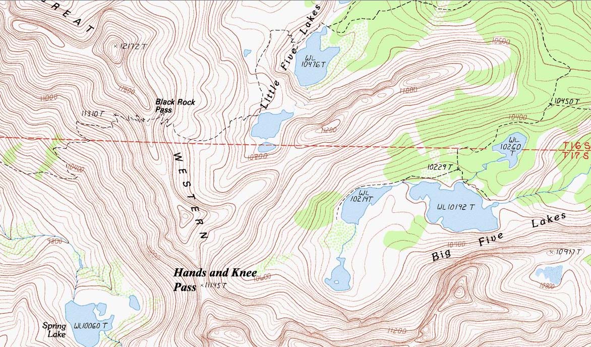
(Some descriptions favor the route through what they call
"Hands and Knees Pass": even assuming that such a pass exists, and that it got
such a silly name, it is a deadly exercise).
As you descend towards Spring Lake (heading for its left-hand side), you
should be able to spot the trail that climbs Black Rock Pass thanks to its
very long switchbacks: it climbs the mountain north of Spring Lake and it
goes higher than the pass you are coming from.
Unless you have binoculars, the views are hard to decipher. North: you are looking at the Great Western Divide. Straight north of Mt Kaweah is Milestone Mt, usually a very visible landmark of the High Sierra, but good luck recognizing it. Even more difficult (to the east) is to recognize any of the Eastern Sierra, except for the highest that has to be Mt Whitney. Roughly (and assuming that you stay on trails wherever possible):
|
1AA + 1AB is the only sensible route: 
1BA would involve climbing the Hands and Knees Pass, which is a colossal waste of time if possible at all. 2 involves a lot of cross-country hiking and a big drop to cross the Big Arroyo. Ditto for 1AA without the 1AB variation. Trailhead:
If you really have to do Hands and Knees Pass:
All the passes:
Road to Mineral King's trailheads: 
Trails around Mineral King: 
|