Southern Utah (2008)

(Click to enlarge)
Pictures of this trip
Itinerary
- FRI 23:
Monument Valley (600 kms from Las Vegas, 180 kms from Chelly, 250 kms from Mesa Verde) - Canyon de Chelly (180 kms from Monument Valley, 240 kms from Mesa Verde)
Time: 6h to drive to Monument Valley, 2h to see Monument Valley, 2 hours to drive to Chelly, 2 hours to see Chelly, 3 hours to drive to Mesa Verde. Sleep in the national forest near Mesa Verde.

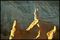
Monument Valley lies entirely within the Navajo Indian Reservation on the Utah/Arizona border (the state line passes through the most famous landmarks). There is only one main road through Monument Valley, US 163, which links Kayenta, AZ with US 191 in Utah. The stretch approaching the AZ/UT border from the north is the most famous view.
The Valley Drive is a 30 km dirt road which starts at the visitor center and loops around the main sites. The most famous structure is the 100-meter high Totem Pole.

Canyon de Chelly lies inside a rim which offers one of the most breathtaking views of the Southwest.
The 50-km South Rim Drive has the most interesting sights: the Tsegi Overlook, the White House Overlook (which offers access via a 4-km round-trip trail to a cliff dwelling), the Spider Rock Overlook (which offers another great view of the canyon walls just across from a 250-meter monolith called "Spider Rock").
- SAT 24:
Mesa Verde (240 kms from Chelly, 250 kms from Monument Valley, 170 kms from Canyonlands, 200 kms from Arches)
and
Arches (60 kms from Canyonlands, 250 kms from Capitol Reef)
Time: 3h to see Mesa Verde, 3h to drive to Arches, 3h to see Arches, 3h to drive to Canyonlands. Sleep near Canyonlands.

The cliff dwellings of Mesa Verde (the most famous Hisatsinom ruin and a World Heritage Site) has 600 cliff dwellings of the Pueblo people dating from A.D. 600 to A.D. 1300, including
the Cliff Palace, the Temple of the Sun, the Balcony House and the Spruce
Tree House.

Arches National Park boasts over 2,000 natural sandstone arches, like the world-famous Delicate Arch.
- SUN 25:
Canyonlands (highlight for me!)
Time: 12h to see Canyonlands, 3 hours to drive to Capitol Reef. Sleep Near Capitol Reef.

Canyonlands is divided into four districts by the Green and Colorado rivers: the Island in the Sky, the Maze, the Needles, and the rivers themselves. The Island in the Sky is the most accessible district. The Horseshoe Canyon Unit has Native American rock art. There are no roads within the park that directly link the four districts and traveling from one district to another is a serious drive because there are few places to cross the Colorado and Green rivers. To reach the Island, take US Highway 191 to Utah Highway 313 (10 mi/16 km north of Moab, or 22 mi/35 km south of I-70) and then drive southwest 22 mi/35 km. Driving time to the visitor center from Moab is roughly 40 minutes. Recommended day hike: Lathrop Canyon. Length: 35 km round-trip to the Colorado River (It starts at the Lathrop trailhead
a few minutes south of the visitor center of Island in the Sky. It heads to the edge of the canyon and then it coasts the rim for a while. After about one hour it
descends into the canyon for about 30'. At the bottom it follows a dry creek bed until it
intersects a dirt road, reached in about 2h30'. Turn right on the road and 100 meters left you will
find the sign for the Colorado river. This second part of the hike, about 1h30', is along a
dirt road. At the very end there are picnic tables. Climb the rocks upstream
to get great views of both bends of the river).
Also: Murphy Loop Length: 14 km round-trip (near the campground).
Next to Delicate Arch at Arches National Park, Mesa Arch (just before the campground) may be the most photographed arch in southeast Utah. Note: the campground of Island in the Sky is very tiny (first come first served).
There is absolutely no water at Island in the Sky (not even at the campground or at the visitor center).
- MON 26:
Capitol Reef (250 kms from Arches, 100 kms from Grand Staircase)
and
Grand Staircase (100 kms from Capitol Reef, 80 kms from Bryce)
Time: 4h to see Capitol Reef, 2 hours to drive to Grand Staircase, 3h to see Grand Staircase, 2h to drive to Bryce. Sleep near Bryce.

Impressive structures are already to be seen along highway 24 east of the park, but the
16-km Scenic Drive of Capitol Reef starts at the park Visitor Center (off the highway 24 that crosses the park horizontally) and provides access to Grand Wash, Capitol Gorge, Pleasant Creek.
Dirt roads that are usually ok for ordinary vehicles lead into Grand Wash and especially Capitol Gorge.
From the parking lot at Capitol Gorge one can continue hiking to the "tanks" (one hour).
The unpaved Caineville Wash Road begins in Caineville, 30 kms east of the visitor center, outside the park on highway 24, and leads after another 30 kms to Lower Cathedral Valley, with the Temple of the Sun and Moon, massive monoliths rising from the desert floor.
There is a campground at Hanksville, east of Capitol Reef, but one can easily camp along highway 24 between Hanksville and Capitol Reef
The Grand Staircase National Monument is 1.9 million acres.
The Staircase is best viewed from the south side of the Monument, one of the classic views is off Hwy 89A, south of Kanab, there is a pull-off called "the Lefevre
Look-out". Arriving from the north, the real highlight is highway 12 between Boulder and Escalante. There is a visitor center in Escalante.
A popular hike is into the slot canyon of Willis Creek: from Cannonville go south on the paved road
and turn right at the sign for Kanab into road 500 until a Trail sign to the
left and a large parking lot on the right.
The same paved road (without turning into 500 for Kanab)
leads to Kodachrome Park, that has odd rock formations and a nice campground. Remember that very few towns have restaurants (nothing between Tropic and Escalante). You can also camp in the nearby Dixie National Forest.
Coyote Gulch is a spectacular place. In theory it lies within Glen Canyon Park,
but it is usually reached from Grand Staircase.
Take Hole in the Rock Road (east of Escalante on hwy 12) for about 50 minutes (which takes easily about 1.5 hours to drive).
The Dry Fork of Coyote Gulch has three narrow tributaries (Peekaboo, possibly the most impressive, Spooky and Brimstone Gulches), and the main canyon does have several slot-like sections of its own.
From the Hole-in-the-Rock road to the junction with the larger Coyote Gulch is about 15 kms.
- TUE 27:
Bryce (80 kms from Escalante, 140 kms from Zion)
and
Zion (140 kms from Bryce, 250 kms from Las Vegas)
and back to Las Vegas
Time: 3h to see Bryce, 3 hours to drive to Zion, 5h to see Zion, 3h to drive to Las Vegas. Sleep in Las Vegas.
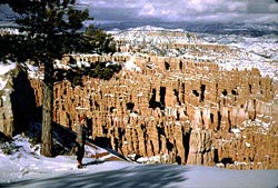
To get to Bryce Canyon from Zion National Park: Take I-15 north to UT-9 (exit 16). Follow UT-9 east through Zion National Park to US-89. Travel north on US-89 to UT-12. Go east on UT-12 to UT-63. Take UT-63 south to the visitor center. Bryce Canyon is famous for its unique geology of red rock spires ("hoodoos") and horseshoe-shaped amphitheaters. Drive to Sunrise, Sunset, Inspiration and Bryce viewpoints. Hike the paved Rim Trail between Sunset and Sunrise Points for outstanding views of the hoodoos from above and the Queens Garden trail (2.9 km round trip), the least difficult trail into the canyon.
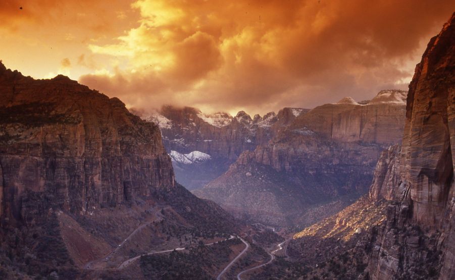
Unfortunately, any hike in Zion Canyon requires using an extremely slow shuttle system. The shuttle starts from the Visitor Center and goes up the canyon.
Recommended day hike: Zion Narrows, at the end of the Riverside Walk, which is the last bus stop. The first 15 minutes are on a paved trail. At the end of the trail, it is popular to hike into the river. Swimming is often required for short sections, but most sections are easily waded. The walls of the gorge are too steep to be climbed, so once inside you have to return the same way.
(A permit is required to hike deeper into the narrows, from Chamberlain's Ranch to Zion Canyon). Another popular hike is to Angel's Landing (about 2 hours up
and 1.5 hour down), from the trailhead at the Grotto. A short fun hike is to
Hidden Canyon
Optional:
Natural Bridges

Natural Bridges preserves some of the finest examples of natural stone architecture in the southwest: three natural bridges named "Kachina," "Owachomo" and "Sipapu."
The Wave:
Paria Canyon-Vermilion Cliffs Wilderness: "The Wave" (permits for Coyote Buttes North must be obtained from Grand Staircase Escalante National Monument Visitor Center in Kanab, a town in Utah, and the trail begins at the Wire Pass trailhead on House Rock Valley Road one hour west of Page. Kanab Visitor Center: 745 E. Highway 89 between 8:30am and 9am. If given the permit, hike the following day at 5am.
Park fees (2008)
- Canyon de Chelly $0
- Mesa Verde $10
- Arches $10
- Capitol Reef $0
- Bryce Canyon $25
- Zion Canyon $25
- Grand Staircase $0
- Monument Valley $5 per person
Camping
Camping is relatively easy both in the national forests and near towns (just avoid the KAO-style of campgrounds that are meant for RVs and are very expensive).
both for flying and for the trunk of the car).
Map of South Utah
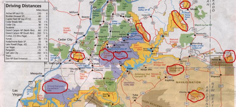
(Click to enlarge)