Hiking University Peak, Eastern Sierra
Notes by piero scaruffi | Other California destinations | California hikes|
University Peak can be hiked from many directions, but, to reach the
summit, you will have to gain the north side. All directions are
relatively easy and straightforward, except that finding the route to the
summit is not trivial.
The route from the south (Center Basin) implies that you first reach Center Basin, which is quite far from every trailhead. You then walk on sandy class-2 terrain all the way to the summit area. The route from the east is via University Pass, a pass easily reached via Lake Robinson from Onion Valley, famous for terrible scree, or directly straight up the east face from Lake Robinson. I think these two are ideal descent routes. The more scenic (north) route from Onion Valley via Matlock Lake is the most frequently used. Via University Pass: north face via Matlock LakeThose who are afraid of University Pass (which always has a lot of scree and loose boulders, and often a lot of snow) can take the longer approach via the Kearsarge Pass trail. This trail is very well marked at the Onion Valley parking lot. It is not my favorite trail: its long switchbacks were obviously designed for mules, not for humans, in the age when mules were more important than hikers. Ignore the first tiny pond. After about 3 kms, you reach the first major lake, Gilbert Lake. About 400 meters after passing this lake pay attention to the trees on your right: one of them bears the sign for Matlock Lake, but it's easy to miss. Turn left into this trail, which is a real trail (not a "use trail" as some descriptions say), and in fact in better conditions than the Kearsarge Pass trail itself (as of 2021). You don't gain much elevation and quickly reach Matlock Lake. The trail continues to its western neighbor, Bench Lake. Stay on the northern shore. From both lakes you can clearly see University Peak's north face towering to the southwest. To the west of Bench Lake there is a two-hump ridge. Leave the trail and climb this ridge (sooner rather than later because the southern section has a lot of steep granite walls and some impassable slot canyons). As you hike up, you realize that Matlock Lake and Bench Lake are part of a group of seven pretty lakes. The price to pay here is the mosquitoes, that may follow you up well above the elevation at which they are not supposed to survive. Keep climbing the ridge towards University Peak and, just when the bouldering begins, you should pass a nameless lake (3460m) on your right. Up to here the route is easy but mark your steps because on the way back it is easy to make a mistake and end up on steep walls of granite. You don't need to descend to lake 3460m. Your goal is to reach the ridge that splits the north face in two.
The route from the last lake:
There is usually a snow patch separating the ridge you are coming from and this ridge, but the top of the snow patch is dry in the summer and becomes a natural trail. The trouble begins after this section. The north face ridge is a pile of loose boulders. While it is rated class-2, it is harder than class-3, and way more dangerous. This "rib" eventually turns into a chute, and this chute splits in two chutes after passing through a sort of "gate". Note: the northeastern ridge has a lot less scree and leads you to the same "gate"
Before the "gate": take the left chute, then move to the right one:
Take the left side until blocked by steep granite, then move to the right one. This one bends slightly left and ends just under the summit ridge. This ridge is a massive wall. You can easily get on this ridge and now you have the first view of the other side (University Pass, Mt Keith, Mt Williamson, etc). Above the "gate" you reach an area where you have a panorama of Owens Valley. The summit is on the west side of the mountain so you have to traverse from the east where you are to the west. Look west for the notch that opens the traverse:
To get through the notch you can climb straight up (not safe) or look for the keyhole (safe):
Now you go downhill a little bit and then uphill again, heading for this second notch:
Climb into the notch and you'll emerge between two summits. The real summit is the one on the left:
Climb to the top along this groove:
Via University Pass: east ridgeFrom Onion Valley take the trail that goes to Robinson Lake. This trailhead is hidden inside the campground (between campsite #7 and #8). If you use this trailhead, the trail immediately veers left and crosses the creek, and then it turns right and coasts the creek to the left (and coming down it is not trivial to find this crossing). But, given the conditions of this trail, you are much better off staying on the right of the creek and ascending through the forest. You can bypass the lake and gain about one hour, besides avoiding the horrible trail that runs to the left of the creek.
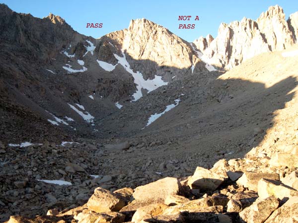
From Robinson Lake (3200m) follow the drainage southwest to the end.
After scrambling over a couple of
moraines, you will reach the point where University Pass is very visible.
(There are descriptions of another way to cross this ridge, variously called
University Pass or "the shortcut" but that's a class-3 chute on both sides
that peaks at almost 4000m of elevation and has snow year-round and
actually takes a lot longer than the obvious pass).
Via Lake Robinson: east faceIf you want to head straight for University Peak's east face bypassing University Pass, the ascent from Lake Robinson is pretty uneventful. To the right (north) of Lake Robinson there is a use trail that goes straight up towards University Peak. You can climb this (eastern) face of the mountain in a million different ways, but you will always end in the same place: the southeastern side of the summit ridge. Move to the right until you are on the eastern side of the summit block and look west for the notch that opens the traverse. See the description from Matlock Lake for how to reach the summit. |
Pictures of this hike
University Peak's weather Highway 395 Sierra mountains View from the top of University Peak (video) |