| To advertise on this page |
A guide to touring...Utahby piero scaruffi |
To advertise on this page |
Back to the main page | Back to Travel resources | Back to the USA
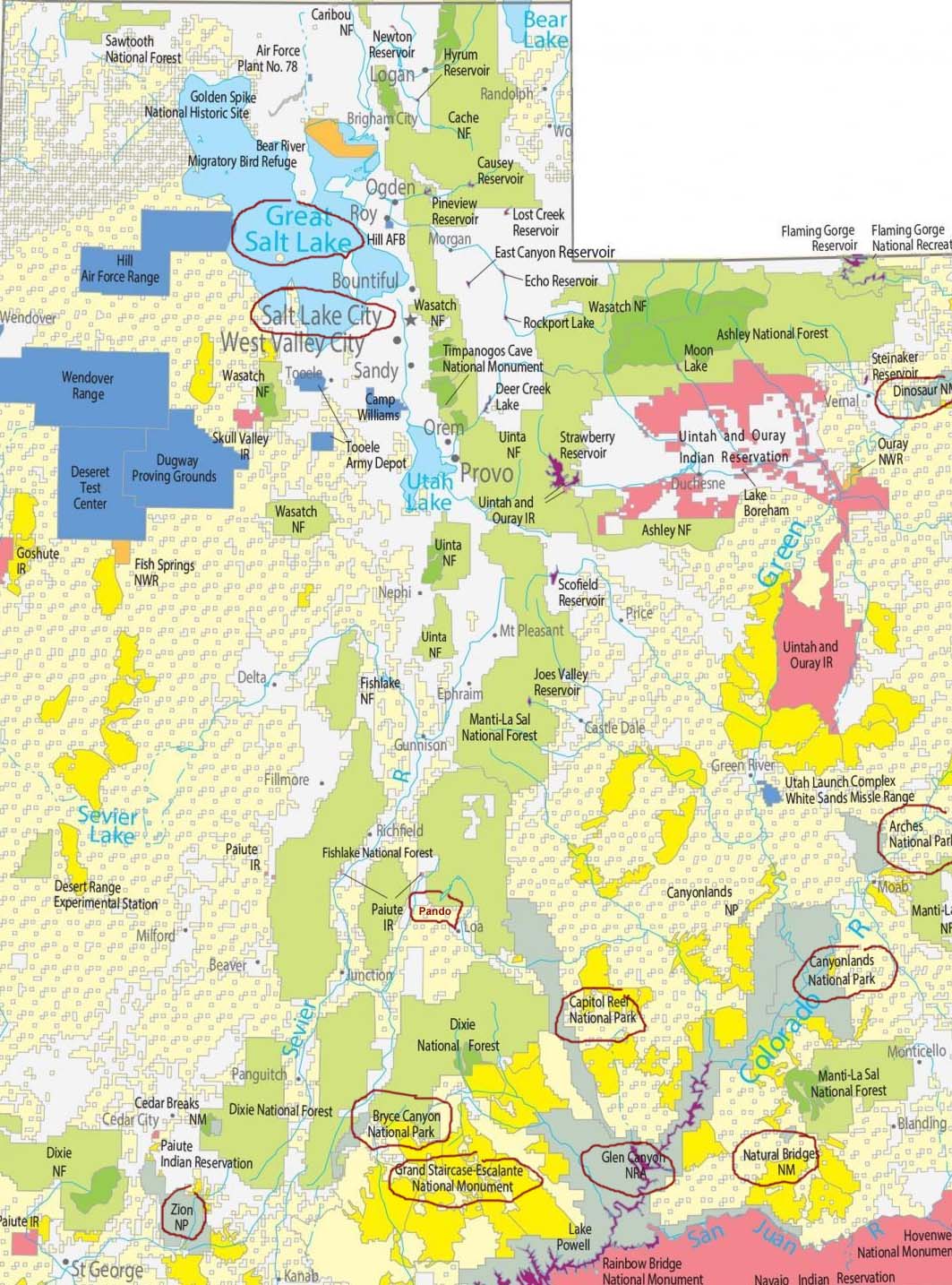
Northern Utah:
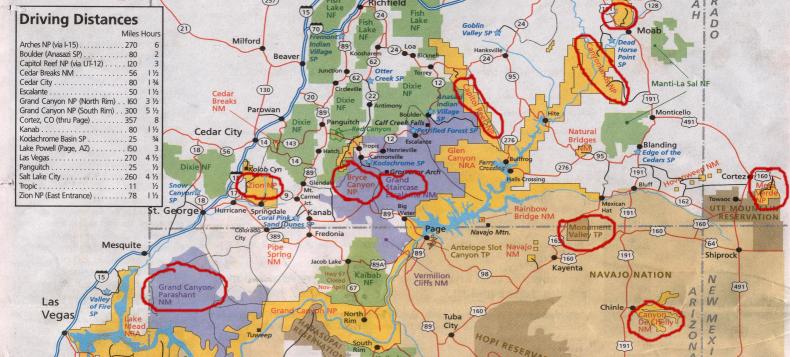
Map of southern Utah attractions:
|
Photos
Buckskin Gulch is one of the narrowest and longest slot canyons in the USA. It is located one hour north of the Grand Canyon's North Rim, near Kanab, in Utah. It is about 4 hours from Las Vegas, 2.5 hours from the North Rim of the Grand Canyon. This hike is not difficult at all, but it is adventurous. It may involve getting very wet. It is an extremely narrow canyon. At points it requires a bit of rock climbing skills. At points it may require wading through small pools of water. Flashfloods can be fatal. From US 89 near milepost 26 (about 6 kms east of the turn off to the Paria ghost town) head south on the dirt road signposted House Rock Valley Rd. The first trailhead (on your left handside) is the the Buckskin Trailhead (most people don't see it because the signpost is off the road). Continue for about 5kms to the Wire Pass Trailhead. This is a broad parking lot that you can't miss. The trailhead is across the road. You are supposed to register and pay $5 (2006). Walk left into the river bed and follow it for about 30/45 minutes until you get to a T junction with Buckskin Gulch (don't miss the petroglyphs at this junction). If you turn left into Buckskin Gulch, you are heading upstream for the Buckskin Gulch trailhead (not very interesting). Instead turn right into Buckskin Gulch and proceed downstream towards the confluence with the Paria river. It is popular to do a one-way hike from Wire Pass to White House, another trailhead located on a dirt road that leaves the highway about 6 km east of House Rock Valley Rd. Things to bring besides the obvious ones: hiking pole, sandals, spare socks. If you do it when it's dry, you don't need sandals and spare socks but you need to be careful about rattlesnakes and tarantulae. A friend did it in 2005 during the flashflood season and the canyon was dry. I did it after the flashflood season and the canyon was very wet. It sounds like conditions are unpredictable. 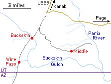 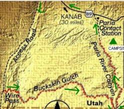
Antelope Canyon, also a slot canyon, is more easily reached from Lake Powell, just east of Page on the Navajo Reservation. This is by far the most photographed slot canyon in the Southwest (Antelope Canyon). It is only 350 meters long, so even elderly people in wheelchairs can see it in 30 minutes. Needless to say, it is extremely expensive: the Navajos force you to take a guide and a shuttle bus, and the charge depends on how friendly the guide is that day, but rarely less than $15 per person (per person) plus a $6 permit. Last time we were able to circumvent the Navajos by driving directly to the gate after hours and walking the 10kms to the canyon. While being the most photographed slot canyon, it is extremely difficult to take photos of it. Not only is it dark and deep, but it is usually full of tourists like you. Unless you are a professional photographer and have a lot of time, you are better off buying the postcards that the Navajos sell for $1 each, and save yourself the $15 entrance fee. The slightly less popular (but nearby) Lower Antelope Canyon is open again after they installed handrails and is slightly cheaper: $13 (plus the same $6 permit). Wave. Only ten people per day are allowed to visit the Wave. I am not sure how the rangers enforce this rule since anybody can drive to the trailheads at any time of the day. To get a permit, you need to be at the Kanab visitor center between 8:30 and 9:00. Yes, you can arrive at 8:59. There is no point in arriving early. They make you fill a form and then you wait till 9. At 9 the ranger gives you a speech about how impassable the road is and how difficult the trail is, hoping that some groups pull out. Then they pick randomly the winners: if the first winner is a group of 10 people, that's the end of the lottery; if it is a lone individual, there are still 9 spots and the lottery continues. They go by group size. The winners get detailed instructions on how to reach the trailhead (there are two entrances, and the south entrance tends to be more manageable by low-clearance vehicles but the rangers always recommend that the winners rent a full-wheel drive vehicle in town). If you take a road that is impassable, you will have to hike the extra distance to the trailhead. In the hot season the hike is further complicated by the heat (there is no water along the route). Whether all this hassle is worth it or not depends on your passion for geological formations. The lottery has certainly made it extramely popular with tourists. Create a lottery and thousands of people will flock to your town from all over the world to see the "rare" attraction. Bryce Canyon. The most popular trail is a loop from Sunset Point to Sunrise Point along the Rim Trail (a flat paved trail) and then down into the bowl of hoodoos, following signs for the Queen's Garden trail, returning via the very popular and very steep switchbacks of the Navajo Loop to Sunset Point. There are many other viewpoints but nothing that compares with these two. More hoodoos can be seen at Fairytale Point, which is just before the entrance; and Bryce Point has some impressive caves. |